The Mt. Ama Dablam Expedition will provide you with one of the most exhilarating experiences in your lifetime. Enjoy the opportunity to climb Mt. Ama Dablam while also spending time at Everest Base Camp and climbing the Kalapathar rocky hills, giving climbers enough time for acclimatisation before summiting Ama Dablam and helping them understand the country's landscape. The Mt. Ama Dablam Peak towers over the Khumbu Valley region near Pangboche, which happens to be the last settlement village before reaching any destination from here. The Mt. Ama Dablam Peak is a lovely mountain named "Mother with a Jewel Box," as this name refers to its unique appearance. The mountain is shaped like a mountain, with a massive block of ice attached to Ama Dablam's neck. The height of Mt. Ama Dablam is 6,812m (22,349 feet), which wasn't previously widely climbed.
DestinationNepal
Duration30 days
GradeAdventurous to Challenging
ActivitiesPeak and expedition
AccommodationTea-House and Lodge
Max. Elevation6812m.
Group SizeMin. 1 Pax
Vehicleprivate vehicles
MealsBreakfast, Lunch, and Dinner during The Trek
Overview
The Mt. Ama Dablam Expedition is arguably one of the best and most adventurous journeys that someone could undertake. Climbing Mt. Ama Dablam while visiting Everest Base Camp and climbing the high Kalapathar rocky hill enables climbers to undertake exercises that facilitate acclimatisation and deepen their understanding of the country's landscapes. Mt. Ama Dablam is an impressive peak located above Khumbu Valley, just near Pangboche – the last permanent settlement on the way to several destinations. Mt. Ama Dablam is a magnificent-looking peak, as its name translates to "Mother with a Jewel Box". As a result of its appearance, a gigantic block of ice and snow is located on Ama Dablam's neck. Mt. Ama Dablam, at an altitude of 6,812 m (22,349 feet), was once relatively unexplored. However, over the last couple of decades, more mountaineers have visited Mt. Ama Dablam, yet they do not come for its attractiveness but for other reasons. Although it is much shorter than other mountains, it still offers an exciting challenge to climbers. According to the available information, Mt. Ama Dablam was first conquered by a team consisting of representatives of different nations – Mike Gill and Wally Romans (from New Zealand). The team managed to conquer Mt. Ama Dablam using one of the most accessible routes along the main Southwest Ridge, accompanied by Barry Bishop (America) and Mike Ward (Britain). However, most people argue that the first ascent of Mt. Everest was made by members of the British expedition in 1953. Mt. Ama Dablam is considered one of the most beautiful mountains in the world. At the same time, it is the most attractive place for climbing in the Himalayas. The peak itself is impressive, attracting tourists year-round. Climbing the peak of Mt. Ama Dablam can be an adventure not only for advanced climbers but also for beginners in mountaineering. Professional climbers and those with sufficient experience, endurance, and physical ability to cope with the peak can also attempt it. To climb Mt. Ama Dablam and enjoy this adventure, one needs to undergo thorough preparation and obtain the necessary assistance from expert climbers. Mt. Ama Dablam is the most difficult mountain to conquer, as it involves vertical climbing.
Ama Dablam Expedition Highlights:
The most beautiful, dominant, and majestic peaks in the Himalayan range.
Enjoy the amazing experience at the summit of the towering, glorious Ama Dablam.
Adventure around a hidden high valley above the mainstream trails.
Trek off the beaten tracks to the base of the scenic Ama Dablam base camp.
Spectacular, glorious views of giant peaks from the top of the Ama Dablam summit.”
A well-thought-out team itinerary that includes acclimatisation, practice climbs, and a summit attempt. An adventurous trip that is made more exciting by its incorporation of the wonderful Sherpa culture amidst the beauty of natural wilderness. The adventure starts off with the main trail to Everest Base Camp. This is an easy trail that goes up and down. We ascended the hill to the well-known Namche Bazaar, passing through several lovely villages filled with ancient traditions. This is followed by a trail to the wonderful Tengboche Monastery in the Khumbu area. This is where you get your first chance to view some magnificent mountains, including Ama Dablam and Mt. Everest. We leave Tengboche and head to the main trail to Everest Base Camp via Pangboche and Dingboche. Upon reaching the mountainous area of Lobuche, we trek to our first stop, Everest Base Camp, enjoying amazing scenery along the way. Experience an amazing landscape where you can stand at the base of the world's tallest peak, Mt. Everest, amid the merciless expanse of ice, snow, and glaciers, near the massive Khumbu Ice-Fall. Our adventurous trip to Everest Base Camp has taken us to the top of Kalapathar, where we can view Mt. Everest, the highest point on earth, in the best possible light. This is followed by a downhill walk to Pangboche village, and then a deviation into a mountain trail towards the base camp of Mt. Ama Dablam. Our mountaineering adventure begins. With ample preparation, one is taken to high camps in preparation for a higher ascent to the summit. After preparing and ferrying the necessary supplies to the advanced camps I, II, and III, we set camp in the high camps before the final summit attempt. Climbing is now done from the High Camp to Camps I and II. These two are the most technically challenging parts of the route. Our mountain climbing difficulty grades are TD and AD. The next point on our route is a mushroom ridge at 6,250 m, where the angle of ascent reaches 90°. You need to use fixed ropes for this section until you reach the summit. After reaching the objective of our trip, one can see the fantastic views of the majestic peaks, including Mt. Everest, Mt. Lhotse, and even Mt. Makalu and Baruntse Himal in the east. After our grand ascent, with a safe descent from High Camp and Base Camp, we start our journey back, leaving behind nothing but our footprint. Going back via gradual ups and downs to Namche Bazaar, Pangboche and Tengboche. We will walk all the way to Lukla, where we will spend the last night of our adventure. The next day is spent flying to Kathmandu after a wonderful Mt. Ama Dablam Expedition.
Itinerary of Ama Dablam Expedition - 30 days
Upon arrival at Kathmandu and Nepal International Airport, you will be greeted by a Team Himalaya staff member and a guide. A short transfer to your respective hotels, checking the lovely rooms, and getting refreshed from jet lag. Join the trek members at the designated meeting place in the hotel for a briefing. Our operator will brief you on dos and don’ts and provide other important information regarding the treks, hotels, local lodges, and trekking/climbing routes. In addition to local culture and religions, changes to flight routes from Manthali Airport in Ramechap now involve taking off from Kathmandu rather than Manthali.
A welcome dinner at a typical, authentic Nepali restaurant, accompanied by folk culture programs from all parts of Nepal, including ethnic traditional dance and music.
Max. Elevation:1300 M
Duration:30 Mins
In Kathmandu, preparations for the Mt. Ama Dablam Expeditions are being reviewed, and the necessary gear is being inspected. Additionally, for a major briefing for the climb, and to carry the necessary items for the expedition.
Max. Elevation:1300 M
Morning after breakfast, loading all the gear for the trek and climb, a pleasant drive to Dhulikhel town. From this old scenic and culturally historical town, heading downhill on a winding road. Reaching low and warm farm country through several rural villages, and then on a dirt track to Manthali, the headquarters town of Ramechap district. Upon arrival in the Middle East, transfer to a local lodge conveniently close to the airport for an overnight stay.
Max. Elevation:518 M
Duration:5 Hours
Distance:128 KM
Morning transfer to Manthali small airport, where a swift, sweeping flight in a small aircraft takes you to Lukla, landing at Tenzing & Hillary Airport.
From the airport at Lukla, after getting organised and taking short, refreshing stops, the walk begins heading through the town of Lukla. From the gate of Lukla, down towards the Dudh Koshi River, past several lovely Sherpa villages adorned with Buddhist monuments. The walk on the gradual winding trail with a few short ups and downs to Phakding village overnight in the comfort of a nice lodge.
Max. Elevation:2830 M
Duration:25 Mins
Distance:74 KM
After a hearty breakfast at Phakding Lodge, having a pleasant overnight halt, the trek begins towards Namche Bazaar. The main hub and capital of the Khumbu Sherpa, the walk follows several smaller villages and crosses bridges over the Dudh Koshi River. Then it reaches the entrance to Sagarmatha National Park (Nepali for Mt. Everest; the Sherpa call it Chomolungma, of Tibetan origin). From the national park entrance, head towards the last village, Jorsalle, for a possible lunch stop. Afternoon walk on a riverbed; they cross a high, last bridge, then head uphill on an undulating, winding, wide, scenic trail to Namche Bazaar. The main trading centre of the Khumbu and Everest region, Namche Bazaar, offers a range of good standard restaurants, pubs, and internet cafes, as well as excellent lodges, hotels, and resorts. The Saturday market is held every week, hence the name Bazaar; it is also known as Namche Bazaar. Enjoy the comfort of a nice lodge for two nights, offering grand views of the Kongde peaks.
Max. Elevation:3440 M
Duration:6 Hours
Distance:10.8 KM
Namche Bazaar is situated at a perfect altitude and is an ideal place for acclimatisation. A short hike up to Syangboche (3, 720 m) is worth a view visit the Everest View Hotel on route panoramic view of Mt. Everest (8, 848.86 m), Mt Lhotse (8, 749 m), Nuptse (7, 861 m), Ama Dablam (6, 856 m), and Kongde with Tharmasarku peaks can be seen as you enjoy warm refreshing cup of tea/coffee. Enjoy a visit to the National Park Museum and the rest of the day at leisure, strolling the streets of Namche Bazaar, which are of great interest.
Max. Elevation:3440 M
Duration:4 Hours
Distance:5.4 Km
The journey to Tengboche begins along a scenic trail high above the glacial Dudh Koshi River. Facing mesmerising views of the Himalayas, the afternoon starts with a few hours' climb to the famous Tengboche Monastery. A grand spot for views of Mt. Everest and an array of peaks. After checking into a nice lodge with time to visit the majestic monastery, enter the main prayer hall, and see a 20-foot statue of Lord Buddha. Treasures are incredibly ornate, including wall hangings, and observe the musical instruments and religious activities of the Lamas and monks. A prayer ceremony is held every evening, during which trekkers are invited to observe it.
Max. Elevation:3867 M
Duration:5 hours
Distance:10.5 Km
Today’s walk is of moderate distance, allowing you to enjoy the morning panorama of Everest and the surrounding snow peaks. The morning starts with a downhill amidst lovely woods, then crosses a bridge with a slow climb up to Pangboche. From here, leaving the tree lines behind for barren country with few bushes of juniper. From Pangboche, a short walk up to Somare for lunch, and then a walk on windswept terrain. The afternoon walk leads to a short descent to a bridge and then up for an hour or more, reaching Dingboche for an overnight halt. Located on a scenic Imjatse valley below Lhotse and Ama Dablam peaks, with views of popular Island Peak
Max. Elevation:4410 M
Duration:5 Hours
Distance:11.5 Km
Dingboche is a great place for a rest day. After breakfast, hike to Nangkartshang hilltop. A good exercise to get acclimatised before heading to higher terrain. From the top, enjoy superb views of Ama Dablam, Lhotse, Nuptse, Lhotse Shar, and Island Peak with Mt. Makalu. After a good hike downhill to the lodge, the afternoon is free at leisure, and you can marvel at the grand surrounding scenery of towering snow peaks.
Max. Elevation:4410 M
Duration:4 Hours
Distance:5.1 Km
Having enjoyed a rest in Dingboche, the adventure continues with a short, steep ascent, followed by a gentle uphill climb to Thugla. A small spot with few tea houses and lodges, where the route from Pheriche and Dingboche joins. A place for lunch before Lobuche. Afternoon, a steep climb for an hour or less to Thugla-La Pass, a small ridge top, and then on a gradual, pleasant walk to Lobuche. Located on a corner, with many nice lodges facing views of Nuptse and Lobuche peaks.
Max. Elevation:4930 m
Duration:5 hours
Distance:8 Km
Start the morning quite early, after breakfast, carrying a packed lunch for the day, and take a slow walk further up. After a few hours, walk with a short climb above the Khumbu glacier, then reach Gorakshep. Our overnight stop after visiting Everest Base Camp lightens the burden of extra items not required for further walks. Having some refreshments or a light lunch, continue walking towards the Everest Base Camp. The trail leads for a few hours over rocks and icy glaciers to Everest Base Camp. Stand beneath the world's highest peaks, Mt. Everest and Lhotse, for a close-up view of the Khumbu Icefall massif. On completing the main highlight of the adventure, return to Gorakshep for an overnight stop after a long day of trekking.
Max. Elevation:5364 m
Duration:7 hours
Distance:11 Km
Early morning climb from Gorakshep to Kala Pathar Hilltop, a strenuous climb of a few hours. Reaching the highest spot of the adventure at 5,545 m rewards you with spectacular views of giant peaks, including Mt. Everest, at a close distance. The hike to Kala Pathar is done early in the morning, at dawn, since the sight of the sunrise is one of the trek's prime attractions. The view is truly something to behold, with the early sunrise and vibrant colour changes on the high Himalayan peaks, from silver to gold. After an enjoyable and mesmerising downhill walk to Gorakshep for breakfast, we walked to Lobuche. Upon reaching Thugla, the route diverts to the Pheriche Valley for lunch. From Pheriche, a few hours of a good walk to Pangboche village for the last overnight in the comfort of a lodge.
Max. Elevation:5645 M
Distance:1.5 km
From Pangboche, we leave the comfort of a nice lodge for tented camping during the approximately two-week climbing period. Leaving Pangboche down towards the Imjatse River to cross a small wooden bridge, from the river, a steep climb of 45 minutes. A walk leads on top of a large meadow around the yak herder's summer huts. Adventure continues on a nice, pleasant, gradual uphill path to Amadablam base camp. The camp is set on a large field below the towering Mt. Amadablam.
Max. Elevation:4580 M
Duration:4 hours
Distance:3.7 Km
A necessary rest day here for preparation and proper acclimatisation, and a short hike around after sorting out climbing gear.
Max. Elevation:4580 m
It is best to set up an extra camp on this exciting and adventurous climb. This allows climbers more time to acclimatise and get organised for the Big Summit bid.
Max. Elevation:5450 m
Duration:4 Hours
Distance:2.5 KM
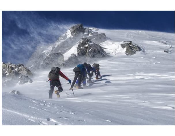
Team Himalaya is reserved for 14 days, allowing ample time for the climb from High Camp to Base Camp and back. A great way to check the route of climb and for acclimatisation. For a week or more of high-altitude activities, all should return to base camp on Day 25. During 14 days, get engrossed in dividing the loads and checking equipment for the final ascent. It is hard to predict the exact day-by-day itinerary for this climbing period; however, the team will be divided into groups that will work on the route to the summit for a few days, then return to Base Camp for rest. The other team marked out the route by fixing ropes and carrying loads to higher camps. From the High Camp, a moraine ridge roughly eastwards to a broad saddle with a view of Mingma-la. From the saddle, head north and climb rocky ground and then through boulders to the ridge below Pt. 5,705, which is the site of camp I. There are four or five tent platforms. From Camp I: Cross a rocky bowl (tricky if snow-covered) until below two rock fingers, then move on to the ridge proper. Climbing the ridge involves severe-grade rock climbing with steps to Camp II. It is located at the top of the yellow tower and offers one of the most challenging pitches on the Technical Difficulties climb. From Camp II: Climb on between the grey tower and the lower rock buttress and climb a snow slope to ' Santa's Grotto' at the start of Mushroom Ridge. Possible with a rest site, following the mushroom crest to a crevasse in the upper face, which provides a nice shelter, and then climbing the snow/ Ice slope to the right of the face, and then following mixed ground to the top of the highest hanging glacier. An ice ridge leads in a marvellous position to the top of the Ama Dablam summit. Rewards: Jaw-Dropping views from the grandstand of the Ama Dablam summit. After a great, tough effort and climb, we made a safe descent to base camp via Camp I and the advanced camp.
Max. Elevation:6814 M
Team Himalaya is reserved for 14 days, allowing ample time for the climb from High Camp to Base Camp and back. A great way to check the route of climb and for acclimatisation. For a week or more of high-altitude activities, all should return to base camp by Day 25. During 14 days, get engrossed in dividing the loads and checking equipment for the final ascent. It is hard to predict the exact day-by-day itinerary for this climbing period; however, the team will be divided into groups that will work on the route to the summit for a few days, then return to Base Camp for rest. The other team marked out the route by fixing ropes and carrying loads to higher camps. From the High Camp, a moraine ridge roughly eastwards to a broad saddle with a view of Mingma-la. From the saddle, head north and climb rocky ground and then through boulders to the ridge below Pt. 5,705, which is the site of camp I. There are four or five tent platforms. From Camp I: Cross a rocky bowl (tricky if snow-covered) until below two rock fingers, then move on to the ridge proper. Climbing the ridge involves severe-grade rock climbing with steps to Camp II. It is at the top of the Yellow Tower, and it gives one of the hardest pitches on the climb of Technical Difficulties. From Camp II: Climb on between the grey tower and the lower rock buttress and climb a snow slope to ' Santa's Grotto' at the start of Mushroom Ridge. Possible with a rest site, following the mushroom crest to a crevasse in the upper face, which provides a nice shelter, and then climbing the snow/ Ice slope to the right of the face, and then following mixed ground to the top of the highest hanging glacier. An ice ridgeline leads to the top of Ama Dablam's summit in a marvellous position. Rewards: Jaw-Dropping views from the grandstand of the Ama Dablam summit. After a great, tough effort and climb, we made a safe descent to base camp via Camp I and the advanced camp.
Max. Elevation:4580 m
Depart from the base camp of Ama Dablam, walk the downhill path and back to a lower altitude and tree lines. The walk leads past Pangboche, and from the bridge, a one- to two-hour climb brings you back to the famed Tengboche Monastery, set amid beautiful scenery.
Max. Elevation:3867 M
Duration:5 Hours
Morning walk on a long downhill to Imjatse River after crossing a bridge, a short, steep up for an hour. The walk follows a gentle, winding path to Namche Bazaar. From Namche downhill to Dudh Kosi River valley and gorge with short ups and downs to the entrance and exit posts of Sagarmatha National Park. Then walk a mere distance to Monjo village for an overnight stop in a nice, quiet village.
Max. Elevation:2830 M
Duration:6 Hours
Distance:8.3 Km
After a great adventure around high Khumbu, enjoy the last day's walk to Lukla on a lovely, gradual, winding trail. Following the path through Phakding and Ghat villages, then a last hour climb to Lukla for lunch and an overnight stop. Enjoy the evening and dinner, celebrating with fellow members, guides, staff, and porters.
Max. Elevation:2800 M
Duration:4 hours
Distance:9.5 Km
From Lukla, the flight departs early in the morning for Ramechap at Manthali Airport. Sometimes flights can be delayed due to bad weather, especially when planes land at Lukla Airport. Walk to the airport and board a small aircraft for a short scenic flight to Manthali Airport at Ramechap. Upon reaching Manthali town airport, transfer to a Team Himalaya vehicle, sized to suit the group, for an exciting drive back to Kathmandu. Upon arrival in Kathmandu, you will be taken to your hotel in the Thamel area. The rest of the evening at leisure till dinner time.
Max. Elevation:518 M
Duration:25 Mins
Distance:74 KM
Team Himalaya reserves an extra two days in Kathmandu in case of flight delays or cancellations due to unfavourable weather at Lukla. If all goes well according to our itinerary, the days will pass smoothly. Enjoy a full rest day for individual activities, or join an exciting sightseeing tour around Kathmandu Valley. The leader and guide will submit the Mt. Ama Dablam mountaineering expedition report to the Ministry of Tourism or the relevant government department.
Max. Elevation:1300 M
At the time of your international flight, homeward bound or to the next port of call, Team Himalaya staff transfers you to the airport. Bid farewell to the staff and Nepal after an enjoyable experience on the Mt. Ama Dablam Mountaineering Expedition.
If the provided schedule isn't suitable for you, we can create personalized travel arrangements.
A "standard package" for the Ama Dablam Expedition is a full-service, all-inclusive option for experienced mountaineers. Ama Dablam is a highly technical and challenging peak, and a standard package covers the extensive logistics, permits, and professional support required for a summit attempt.
Book your own private small group trip
**Discounts are determined exclusively by the size of your group. We do not add additional members to your group.
June 2026
Su
Mo
Tu
We
Th
Fr
Sa
31
1
2
3
4
5
6
7
8
9
10
11
12
13
14
15
16
17
18
19
20
21
22
23
24
25
26
27
28
29
30
1
2
3
4
Sold out dates
US $0US $0 per person (based on 1 people)
Cost Includes
Transportation to and from the airport.
Meals at breakfast, lunch, and supper while on the hike.
A porter and all of his costs.
Meals at breakfast, lunch, and dinner while on the hike.
Climbing permits.
Sleeping bags and down jackets (available upon request).
After dinner (while on the trip), seasonal fresh fruits.
A private vehicle-driven full-day guided city tour in Kathmandu (Day 2).
Guide and porter insurance.
Flight tickets from Kathmandu to Lukla and return.
Lodging fees while on the expedition include licensed, knowledgeable, and English-speaking tour guides.
Expert Sherpa mountaineering guide
Sherpa staff members, such as guides, porters, and cooks
Spend three nights in a twin-sharing room at the best hotel in the city (Kathmandu).
Trekking Permit and TIMS.
Welcome and farewell dinners with traditional ethnic music and dance at one of the best Nepalese restaurants.
On a trip to five hot showers with an attached bathroom
High-quality tents, cooking equipment, and a duffel bag from Team Himalaya are also included.
Cost Excludes
The price of further trips.
The expense incurred for the city trip.
WiFi, additional hot baths, and battery charging while trekking.
An additional porter charge.
Meals are eaten in city areas, except for breakfast and the previously mentioned special dinner.
Arrival visa for Nepal.
Tipping staff members (as an act of gratitude).
Travel insurance that includes rescue and evacuation in case of an emergency.
Individual climbing gear
Expenses for oneself.
Route Map
Loading map...
Know Before you Go
Best Time to Go
The most favourable time for the Ama Dablam Expedition is during the spring (March to May) and autumn (September to November) seasons. These periods offer the best balance of stable weather, mild temperatures, and excellent visibility. During spring, the trekking routes come alive with vibrant rhododendron blossoms, vibrant valleys, and pleasant daytime warmth, though snow may still linger at higher altitudes. Autumn brings crisp, dry air with spectacularly clear skies, making it ideal for photography and safe climbing. The views of Everest, Lhotse, and Makalu from the summit are exceptionally vivid during these months.
The winter season, from December to February, is harsh and cold, with heavy snowfall that makes climbing routes difficult and dangerous. Meanwhile, the monsoon season from June to August is often clouded by heavy rain and poor visibility, increasing the chance of landslides and flight delays. For these reasons, most climbers choose either the post-winter freshness of spring or the stable conditions of autumn for a rewarding and safe expedition.
Additional Tip: Plan your summit push for early morning hours to avoid strong afternoon winds and to enjoy panoramic sunrise views over the Himalayas.
Difficulty
Although Ama Dablam (6,812 m) is smaller than some of the Himalayan giants, it is considered one of Nepal’s most technical and challenging peaks to climb. The mountain’s elegant shape hides steep ridges, icy walls, and exposed faces that require solid mountaineering skills. The ascent demands proficiency in using fixed ropes, ice axes, ascenders, crampons, and abseiling equipment. Climbers must also be comfortable navigating mixed terrain, including rock, snow, and ice.
The most difficult section lies between Camp I and Camp II, where climbers face near-vertical rock pitches, fixed lines, and narrow ridges. Beyond Camp II, the route becomes icy and more exposed, testing endurance and precision. The climb is graded between AD (Assez Difficile) and TD (Très Difficile), which translates to “fairly difficult” to “very difficult” on the Alpine scale. This classification highlights that Ama Dablam is a mountain for experienced mountaineers, not beginners. Mental toughness, technical knowledge, and physical preparation are essential for success.
Additional Tip: Before the expedition, train with rope techniques, ice climbing, and long hikes carrying a weighted backpack to simulate the real conditions on Ama Dablam.
Accommodation and Food
During the trek to Ama Dablam Base Camp, climbers stay in teahouses and mountain lodges that provide basic but comfortable accommodations. These lodges usually have twin-sharing rooms with warm blankets and offer a cosy place to rest after long trekking days. Meals served on the trail include a mix of Nepali and Western cuisine such as dal bhat, soups, pasta, fried rice, noodles, omelettes, and vegetable curries. Meals are basic yet wholesome, offering enough nutrients to sustain energy during the trek and help the body adjust to higher altitudes.
Once climbers reach the Ama Dablam Base Camp, the expedition becomes fully supported by camping facilities. Here, accommodation includes high-quality mountain tents, dining tents, and kitchen tents managed by trained cooks. Meals at base camp and higher camps consist of energy-dense and easily digestible foods, including rice, pasta, boiled potatoes, soups, and dehydrated meals suitable for high-altitude conditions. The cooks ensure proper hygiene and maintain a balanced diet to keep climbers energised. Water is treated by boiling or other purification methods to ensure it is safe to drink.
Additional Tip: Carry lightweight snacks like protein bars, dried fruit, and chocolate for extra energy during climbing sections when access to meals is limited.
Permits
Climbing Ama Dablam requires several official permits and documents that authorise entry into the mountain and surrounding conservation areas. These include the Ama Dablam Climbing Permit issued by Nepal’s Department of Tourism, Sagarmatha National Park Entry Permit, and the Khumbu Pasang Lhamu Rural Municipality Entry Permit. Each permit helps maintain the trail, fund rescue services, and support local development projects.
Climbers must always carry the permits, as they are often checked at checkpoints along the route. The fees collected from climbers also support the preservation of the fragile Himalayan environment and the livelihood of Sherpa communities who depend on tourism. At Team Himalaya, we handle all necessary permits for you, ensuring a smooth, hassle-free process.
Additional Tip: Keep digital copies of your permits and identification cards in your phone or cloud storage in case the physical documents are lost or damaged during the trek.
Cultural and Historical / Monasteries
The region surrounding Ama Dablam is rich in Sherpa culture and Buddhist spirituality. As climbers pass through villages such as Namche Bazaar, Pangboche, and Tengboche, they experience the daily life of the Sherpa people, known for their hospitality, resilience, and deep spiritual connection with the mountains. Along the trail, colourful prayer flags flutter in the wind, mani walls are engraved with sacred chants, and prayer wheels spin with every step of a pilgrim or trekker.
The Tengboche Monastery, one of the most important religious sites in the Everest region, sits atop a hill overlooking Ama Dablam and Everest. Many climbers receive a blessing from the monks before beginning their ascent. The monastery’s calm atmosphere, combined with the chanting of prayers and the scent of incense, offers a profound spiritual experience that complements the physical challenge of the expedition. The mountain itself, known as the “Mother’s Necklace,” holds special significance in Sherpa beliefs, symbolising beauty, protection, and purity.
Additional Tip: Always show respect inside monasteries by removing your shoes, speaking softly, and seeking permission before taking photographs.
Acclimatisation / Altitude Sickness
Proper acclimatisation is a crucial part of the Ama Dablam Expedition. The body must adapt gradually to the decreasing oxygen levels as altitude increases. The itinerary usually includes rest days in Namche Bazaar and Dingboche, where climbers take short hikes to higher points and return to sleep at lower altitudes. This steady method reduces the risk of Acute Mountain Sickness (AMS). This can cause headaches, nausea, fatigue, and dizziness.
Climbers are advised to stay hydrated, eat high-energy foods, and avoid alcohol or sleeping pills during the expedition. Guides constantly monitor the team for any symptoms of altitude-related illness and carry oxygen cylinders and first-aid kits. If symptoms worsen, immediate descent is the safest and best course of action. Acclimatisation hikes also help strengthen muscles and prepare climbers for the final push to higher camps.
Additional Tip: Follow the “climb high, sleep low” principle—ascending slowly and descending slightly during sleep helps your body adjust more quickly to altitude changes.
Packing List
Packing well is important for Mera Peak. Here’s what you should bring:
Clothing: Thermal base layers, fleece jackets, an insulated down jacket, a waterproof and windproof shell jacket, trekking pants, insulated climbing pants, waterproof over pants, a warm hat, a balaclava, a buff or neck gaiter, thermal socks, and several pairs of trekking socks.
Footwear: Sturdy trekking boots for the lower trails, insulated mountaineering boots for climbing, crampon-compatible climbing boots, and lightweight camp shoes or sandals.
Climbing Gear: Climbing harness, helmet, ice axe, carabiners, ascenders, belay device, ropes (usually provided by the expedition team), gaiters, and climbing gloves.
Sleeping and Camping: A four-season sleeping bag, an insulated sleeping mat, a lightweight pillow, a duffel bag or backpack, dry bags to keep gear dry, and a headlamp with extra batteries.
Accessories and Essentials: Trekking poles, sunglasses with UV protection, sunscreen, lip balm, reusable water bottles or hydration bladders, water-purification methods, such as tablets or a portable filter, a small personal medical kit, a multi-tool or knife, toiletries, and lightweight, quick-dry towels.
Snacks and Extras: Energy bars, nuts, chocolates, rehydration salts, tea bags or coffee sachets, a camera, binoculars, and a journal for personal notes.
Electronics: Power bank, portable solar charger, and extra memory cards for cameras.
Tip: Use waterproof dry bags to separate clothes, gadgets, and food. This will protect your gear and make it easier to access when needed.
Insurance
Comprehensive travel and mountaineering insurance is mandatory for all climbers. The policy should cover emergency helicopter evacuation, high-altitude medical treatment, hospitalisation, trip cancellation, and loss of equipment. Mountain weather can change suddenly, and having proper insurance ensures that rescue operations and medical services are financially covered in the event of an emergency. Before starting the expedition, our company asks climbers to provide proof of comprehensive insurance coverage.
It is strongly recommended that you verify your insurance specifically covers mountaineering above 6,000 meters, as many general travel insurance plans do not cover the risks associated with high-altitude climbing. Keep a copy of your insurance policy and emergency contact details with you at all times during the expedition.
Additional Tip: Contact your insurance provider before departure to confirm that rescue operations in Nepal are included under your plan.
Transportation
Your expedition kicks off with a roadway trip from Kathmandu to Manthali, located in Ramechhap, followed by a short flight to Lukla, one of the world’s most famous mountain airports. The flight offers breathtaking Himalayan views and marks the start of journeys into the Everest region. From Lukla, the trekking route passes through Phakding, Namche Bazaar, Tengboche, and Pangboche, eventually reaching Ama Dablam Base Camp.
The trek itself is a cultural and natural experience, offering views of suspension bridges, alpine forests, and Sherpa villages. Most expedition companies manage all ground transportation, domestic flights, and luggage transfers. Flights to and from Lukla are weather-dependent, so flexibility in your schedule is important to accommodate potential delays.
Additional Tip: Leave an extra day or two in your travel plan to account for flight cancellations or delays due to unpredictable mountain weather.
Electricity and Communication
Electricity is available in most teahouses along the trekking route, where devices can be charged for a small fee. As you climb higher, access to electricity becomes limited, so carrying a solar charger or power bank is essential. Wi-Fi is available in major settlements such as Namche Bazaar and Dingboche, but connection speeds decrease with altitude.
During the climb, communication between climbers and base camp is maintained through walkie-talkies or satellite phones to ensure safety and coordination. Expedition leaders also use satellite communication to update weather forecasts and emergency contacts. In remote camps, conserving battery life is important, so it is best to keep devices switched off when not in use.
Additional Tip: Store electronic devices and batteries inside your sleeping bag at night to keep them warm and extend their battery life.
Drinking Water
Staying hydrated with clean drinking water is vital for health while trekking at high altitudes. Along the trekking route, teahouses provide boiled or filtered water for a small charge. However, using water purification tablets or portable filters offers additional protection against bacteria. It is not recommended to drink untreated water from streams or taps, as it may cause stomach infections.
Drinking at least three litres of water each day is recommended to prevent dehydration and reduce the risk of worsening altitude sickness. Using a refillable water bottle or hydration system not only helps you stay hydrated but also reduces the use of single-use plastic bottles, supporting environmental conservation efforts.
Additional Tip: Add electrolyte powder or rehydration salts to your water to replenish minerals lost through sweat and to maintain energy throughout the day.
Guide and Porter
Professional guides and porters are the backbone of a successful expedition. Certified mountain guides lead the team through technical routes, ensuring safety and proper rope management. They also assist with setting up camps, managing gear, and providing moral support. Porters carry heavy equipment, tents, food supplies, and personal belongings, allowing climbers to conserve their strength for the actual ascent.
Ethical trekking agencies ensure that guides and porters are properly insured, well-equipped with warm clothing, and paid fair wages. This not only promotes responsible tourism but also strengthens the bond between climbers and local communities. A respectful relationship with your guide and porter adds immense value to the journey.
Additional Tip: Showing appreciation with a kind thank-you gesture or small gratuity at the end of the expedition is a great way to support your Sherpa team.
Health and Fitness
Climbing Ama Dablam demands high levels of physical fitness, endurance, and mental resilience. Training should begin several months before departure and include cardiovascular exercises such as running, swimming, and cycling, as well as strength training focused on the legs and core. Long hikes carrying a weighted backpack will help your body prepare for the physical challenges of high-altitude mountaineering.
In addition to physical training, a balanced diet, sufficient rest, and stress management, these are essential for a successful ascent. Preparing mentally is just as important, since maintaining calm and concentration is crucial in extreme environments. Practising breathing techniques and positive visualisation can help you perform better under pressure.
Additional Tip: Include stair climbs and hill sprints in your workout routine to mimic steep ascents and build strong leg muscles for the expedition.
Responsibility and Sustainability
Sustainability is an essential aspect of modern mountaineering. It is recommended that climbers follow Leave No Trace practices by properly managing and disposing of their trash, minimising plastic use, and respecting local culture and wildlife. Supporting locally owned lodges, hiring Sherpa guides, and buying regional products contribute to the economic well-being of mountain communities.
Environmental awareness is also vital at base camp and higher camps, where waste management is a growing challenge. Many expedition teams now carry all waste back to lower settlements for proper disposal and use solar power instead of fuel when possible. Protecting the natural beauty of Ama Dablam ensures that future generations can experience its magnificence as we do today.
Additional Tip: Carry a reusable cup, water bottle, and utensils to help reduce plastic waste and inspire other trekkers to adopt eco-friendly habits.
We had a very successful EBC trek in October 2024 because of Team Himalaya! Our guide, Raj, was very knowledgeable in all things Everest. He set us up in the best lodges where we had great service all along. He provided us with a superb porter, who also went above and beyond in taking care of us. Raj was very patient with us and was always looking out for our best interests. We would highly recommend Team Himalaya for any trek!
AAlec S1st Apr, 2024
Everest Base Camp Team Himalaya March 2024
We have just returned from a 14 day, 11 day hike with Raj and Durga from Team Himalaya to Everest Base Camp. From the minute we landed to our departure we were properly looked after and cared for by Team Himalaya. The trek to and from Everest Base Camp was wonderful, our guides and porters really looked after us and were incredibly knowledgeable. In Nepal things can go wrong especially with flights to and from Lukla but Team responded magnificently and found alternative solutions. If this is on your bucket list as ours and you are looking for a company to organise this with I would 100% recommend Raj.
JJourney379926937861st Apr, 2024
Reaching Everest Base Camp with TEAM HIMALAYA
If you are looking for an adventure of a lifetime, don’t hesitate! Choose TEAM HIMALAYA for your Everest Base Camp trek! We completed the EBC trek early November 2023 . My husband and I chose to do a private trek with Team Himalaya. Everything went smoothly with our guide Raj. His team and organization is outstanding! We could not have done it without him. Raj took care of everything throughout the trek and made sure we were well at all times, even providing us fresh fruits every night after dinner! We felt safe at all times , his experience and knowledge of the Himalayas helped us achieve our goal in reaching the EBC! His professionalism went beyond our expectations from our first contact with him for information until the very end. We will forever remember this expedition and gained a friend in our guide Raj!
eevanhH6577DL13th May, 2023
Incredible Experience by evan
It was an incredible experience being surrounded by the towering Annapurna Himalayas. This memorable trek through Nepal offered the best scenic views and stunning landscapes. Despite being surprised at how quickly the trek ended, the daily walks were filled with dramatic views that left a lasting impression.
I highly recommend this adventure, as it is one of the best base camp treks in the Himalayas with minimal risk of altitude sickness. Although there were steep ups and downs that were tiring on some days, the breathtaking views made it all worth it. This was easily the most exciting trek I have ever experienced.
I want to thank Team Himalayas and Raj for providing exceptional service with their expert guide and staff.
Frequently Asked Questions About the Ama Dablam Expedition
What is the best time to climb Mt. Ama Dablam?
Ama Dablam is best climbed during the spring months of March to May. The autumn months of September to November, when conditions are generally calm, skies are clear, and the mountain offers optimal visibility. This allows climbers to enjoy unobstructed views of the Himalayan peaks.
How difficult is the Ama Dablam climb?
Ama Dablam is a technically demanding mountain that requires good climbing experience. The expedition includes steep rock faces, ice slopes, and mixed terrain. While shorter than Everest or Lhotse, it challenges climbers with its technical sections and high-altitude conditions.
What type of accommodation is available?
Accommodation along the trekking route includes teahouses and lodges with basic facilities. During the actual climb, climbers stay in tented camps at Base Camp and higher camps. Lodges offer simple meals, clean rooms, and hot water at some locations.
What permits are required for the expedition?
Climbers are required to secure both the Sagarmatha National Park Entry Permit and the Khumbu Pasang Lhamu Rural Municipality Permit before starting the expedition. In addition, a climbing permit for Mt. Ama Dablam is mandatory. These permits are arranged through our company and can be collected either at the starting point or at the official checkpoints along the route.
Are guides and porters necessary?
Engaging experienced guides and porters is strongly recommended to ensure safety, provide technical support, and make the expedition more convenient. Guides offer technical support and route knowledge, while porters help carry gear and supplies. Their presence significantly enhances the chances of a successful summit.
How should one prepare physically for the expedition?
Physical preparation should include cardiovascular exercise, long hikes with a loaded backpack, and leg and core strength training. Endurance and stamina are crucial for managing long trekking days and high-altitude climbs.
Is mental preparation important?
Yes, mental readiness is essential. Climbers must remain calm, focused, and composed in extreme conditions, including technical climbs and sudden weather changes. Strong mental resilience supports decision-making and safety at high altitudes.
What is the risk of altitude sickness?
High-altitude conditions increase the risk of Acute Mountain Sickness (AMS). Symptoms include headache, nausea, dizziness, and fatigue. Proper acclimatisation, gradual ascent, and adequate hydration are key to reducing these risks.
How is acclimatisation managed during the expedition?
The itinerary includes rest days at Namche Bazaar, Dingboche, and Base Camp for acclimatisation. Climbers gradually ascend to higher altitudes and may return to lower camps to adjust. Practice climbs before the summit bid also aid proper acclimatisation.
What kind of food is provided?
Meals on the trek are simple yet nutritious, designed to sustain energy and support acclimatisation. Breakfast, lunch, and dinner typically include rice, noodles, vegetables, soups, and occasional meat. Hydration is emphasised alongside meals.
How is drinking water handled?
Safe drinking water can be obtained by boiling, filtration, or using purification tablets. Maintaining hydration is essential to prevent dehydration and altitude sickness. Trekkers often carry reusable water bottles or hydration systems for convenience.
What kind of insurance is required?
Travel and climbing insurance covering high-altitude trekking is mandatory. Standard policies often do not cover extreme-altitude expeditions, so specialised coverage is necessary. Proof of insurance is required before the expedition begins.
How long does the expedition take?
The Ama Dablam expedition typically lasts about 30 days, including acclimatisation, trekking to Base Camp, summit attempts, and return to Kathmandu. The climb from Base Camp to the Ama Dablam summit typically takes about two weeks, allowing sufficient time for acclimatisation and setting up higher camps.
What transportation is used during the expedition?
The Ama Dablam journey begins with a picturesque drive from Kathmandu to Manthali (Ramechhap), the entry point to the Everest region. From there, participants take a short flight to Lukla before continuing on foot through traditional Khumbu villages and scenic trails. All climbing gear and supplies are transported either by climbers or assisted by porters along the route.
How are electricity and communication managed?
Electricity is available at lodges for charging devices, often via solar panels or generators. Satellite phones or local SIM cards provide communication options in higher areas. Some Base Camp camps may have limited connectivity.
Are there cultural or historical sites along the route?
Yes, trekkers pass through Sherpa villages and monasteries, including Tengboche Monastery, which holds religious significance. These stops offer insight into local culture, traditions, and Buddhist practices.
How is waste and environmental responsibility handled?
Climbers are expected to follow Leave No Trace principles. Waste must be disposed of responsibly, and climbers should minimise their impact on the fragile high-altitude environment. Camps and trails are kept clean to preserve the region.
How do weather conditions affect the climb?
The weather can be unpredictable, with sudden snowstorms, wind, and temperature drops. Summit attempts depend on clear safety conditions. The most reliable weather for climbing Ama Dablam is in spring and autumn, when skies are clearer, and trails are safer for the expedition.
What level of health and fitness is required?
A high level of physical fitness is required, including endurance, strength, and cardiovascular conditioning. Experience in trekking and climbing at moderate to high altitudes is strongly recommended for safety and success.
What happens after the climb is completed?
After a successful summit, climbers descend to Base Camp, then trek back through the Khumbu Valley to Lukla. The expedition concludes with a scenic flight to Ramechhap and a drive back to Kathmandu, where climbers can rest and recover.


![Island+Peak+[2013 03 30+ +0508]](/_next/image?url=https%3A%2F%2Ffis-api.teamhimalaya.com%2Fmedia%2Ftrip-gallery%2Fmedia-fb1da565-1748424946.jpg&w=1920&q=75)