When deciding between the Manaslu Circuit Trek and the Annapurna Circuit Trek for 2026, there is no doubt that it is a choice between remoteness and modern conveniences.
The Manaslu Circuit Trek will be ideal if you prefer a raw cultural experience, where treks are done only on foot, with no roads disrupting your path and fewer people around. The Annapurna Circuit Trek would be better suited if you prefer more comfortable teahouses with Wi-Fi and hot-water showers, as well as varied microclimates.
The Reality Shift: What Has Changed in 2026?
The trekking experience in the Nepal Himalayan mountains has changed dramatically in recent years, and 2026 is a turning point for both treks.
To compare these two famous circuits, one must first examine the development of their infrastructure. One cannot read too many online forum discussions without encountering an article suggesting that the advent of modernity has "spoiled" Nepalese trekking. It is not that simple, however: the trekking trails themselves have changed, becoming two very distinct kinds of treks.
Annapurna Circuit: ──(Jeep Road Integration)──> Fast Access, Comfortable Teahouse, Hybrid Trail
Manaslu Circuit: ──(Restricted Area Regulations)──> Isolated Hiking, Authentic Tibetan Culture, Required Guide
Road Construction & Trail Integrity
The effect of roads that can accommodate cars and jeeps is one of the most crucial determinants for trekking enthusiasts from other countries.
The Annapurna Circuit Road Reality
The trek from Besisahar on the east side up the Marsyangdi Valley to Manang is possible because there is an existing dirt road. On the western side, an operational road runs through the Kali Gandaki Valley from Jomsom, via Muktinath, to Tatopani.
Drawback: It will be dusty and noisy because jeep and motorcycle transport are plentiful along this road in the spring and autumn.
Advantage: The road does not mean you have to take it as your mode of travel. In fact, the Annapurna Circuit Trek takes you off the road, making your journey more pleasant. The road also helps travellers save time by allowing them to travel through lower valleys, thereby condensing a 21-day trail to 12-14 days.
The Manaslu Circuit Trail Preservation
The sharp difference in this regard is evident on the Manaslu Circuit Trek 2026, where, after crossing the entry point at Jagat, the trek becomes a real, roadless trekking area once again. This trek lies in a very remote area under the jurisdiction of Chumnubri, which makes any kind of transportation impossible; thus, you would need to backtrack on foot or hire a helicopter if required.
Crowds, Solitude, and Cultural Authenticity
The mood on the trail will dictate the interactions with local people and landscapes.
-
Manaslu (The Cultural Sanctuary): Because Manaslu is categorised as a restricted area, visitor numbers are controlled. There are some upper villages, such as Lho, Namrung, and Samagaun, that are strongly connected to Tibetan Buddhist culture. Ancient mani walls, active monasteries, and locals in their traditional Tibetan clothes will become your companions for a few days. In 2026, Manaslu will provide you with a relaxed atmosphere that once made Nepal famous worldwide among trekkers.
-
Annapurna (The Global Hub): The Annapurna Circuit Trail is widely regarded as one of the most popular trekking destinations worldwide. The trail will present you with an amazing opportunity to meet locals of different ethnic origins, including Hindu Brahmin and Chhetri in the subtropical zones and Gurung and Thakali in the rain-shadow high mountains.
Pass vs. Pass: Larkya La vs. Thorong La
Both involve making an extremely challenging pass at high altitudes, requiring great cardiovascular strength and resilience.
Larkya La Pass - Manaslu ──> 5,160 m (16,929 ft) | Harder and more challenging glacier crossing terrain
Thorong La Pass - Annapurna ──> 5,416 m (17,769 ft) | Higher altitude but wider and more extensively used
Larkya La Pass (5,160 m)
Slightly less than Thorong La in elevation, Larkya La is more strenuous than Thorong La physiologically. One ascends Larkya La ($4,460 m) before dawn at about 4:00 AM. The trek through the moraine, a long, steady ascent of rocks, poses a challenge to the knees during a full eight to ten-hour walking day.
Thorong La Pass (5,416 m)
Thorong La Pass represents the highest point on both trekking routes. The atmospheric pressure at this location is about half that found near sea level. Even though Thorong La is located at an even higher elevation than Khangsar Pass, the trekking path remains broad, frequently travelled, and well-maintained with help from local porters and mules.
Teahouse Infrastructure and Comfort Standards
Your level of comfort at the end of a long hiking day plays a massive role in cumulative fatigue.
|
Feature |
Manaslu Circuit Trek |
Annapurna Circuit Trek |
|
Lodging Style |
Traditional, basic alpine teahouses |
Developed mountain lodges & boutique guesthouses |
|
Private Bathrooms |
Rare; available only in a few lower villages |
Common; widely available up to Manang |
|
Wi-Fi & Cellular Connection |
Highly unstable; satellite internet tokens required |
Reliable cellular data (Ncell/NTC) and Wi-Fi |
|
Food Selection |
Standard Dal Bhat, noodles, basic eggs |
Expansive menus, espresso bars, and fresh bakeries |
|
The "Survival Test" |
Dharamsala ($4,460 m) features cold, basic dorms |
High Camp ($4,925 m) has heated dining halls |
Permits, Regulations, and Booking Rules
The entry requirements for administration purposes in both regions are entirely different.
Manaslu Circuit Requirements (Strict Regulations)
There will be no independent trekking at all.
In order to obtain the Manaslu Restricted Area Permit (RAP), the following requirements must be fulfilled:
1. A registered guide from the government must be hired.
2. The permits have to be obtained via a licensed trekking agency in Nepal.
Annapurna Circuit Requirements (Flexible Access)
Annapurna Circuit trekking requires nothing but the usual conservation regulations. You simply need a valid ACAP permit and your TIMS card. The authorities strongly advise all trekkers to hire a local guide, but aside from that, there are no strict restrictions on group numbers or on registering with trekking agencies.
The Manaslu Circuit Trek: Detailed Day-by-Day
It is an unavoidable journey on foot across a restricted wilderness strongly influenced by the pure culture of the Tibetan civilisation.
Day 1 –Drive from Kathmandu to Machha Khola (930m)
Time/Distance: 8 - 9 hours driving (~160 km)
Reality: You leave the capital city via the smooth Prithvi Highway, but after Arughat Bazar, the last 3-4 hours are spent on an absolutely rough dirt road, directly cut into the river corridor of the Budhi Gandaki. It is a very long day.
Day 2 –Trekking from Machha Khola to Jagat (1,340m)
Time/Distance: 6 - 7 hours walking (~22 km)
Reality: Start to walk and follow the banks of the raging river, climb rocky landslides, meet local Gurung villages and cross the first impressive swinging suspension bridges. You stop by natural hot springs in Tatopani and finally walk up to the stone staircase, which leads you to the police checkpoint at Jagat.
Day 3 –Trekking from Jagat to Deng (1,860m)
Time/Distance: 6 –7 hours walking (~20 km)
Reality: Enter the narrow gorge of the Budhi Gandaki River, climb high rocky ridges, hike under hanging waterfalls, and pass through forests with bamboo and subtropical trees that are now becoming more frequent. Cross the river several times and arrive at the small forest settlement of Deng.
Day 4 –Trekking from Deng to Namrung (2,630m)
Time/Distance: 7 - 8 hours walking (~18 km)
Reality: Longest climbing day of the lower circuit. Climb continuously from the humid valleys of lower altitude up to cool coniferous and silver birch forests. First mani walls (stone Buddhist prayers) and colourful prayer flags appear; your path enters the high mountain range; first sightseeing of the highest peaks, provided that the weather is favourable.
Day 5 –Trekking from Namrung to Samagaon (3,520m) via Lho
Time/Distance: 6 -7 hours walking (~19 km)
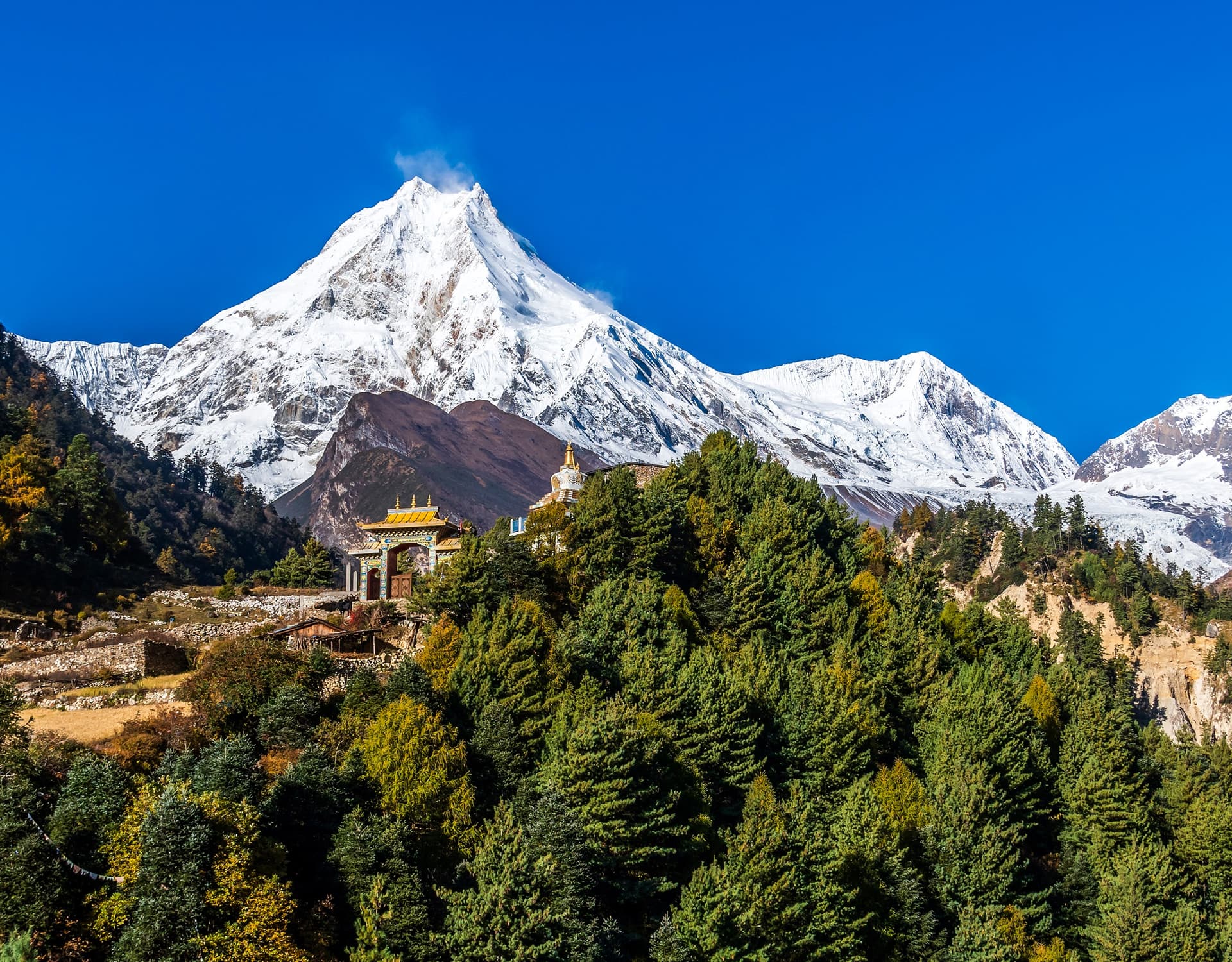
Reality: Open up to a spectacular, wide valley with impressive views all around. Cross stone houses of Lho Village; visit Ribung Gompa, an old Buddhist Monastery situated against the background of impressive Mt.Manaslu (8,163m). Stay overnight at the Nubri cultural centre.
Day 6 –Acclimatisation Rest Day in Samagaon (3,520m)
Reality: A necessary pause to give your body time to adapt to increasing altitude. Hike three hours one way to Birendra Lake (3,691), a small lake situated at the base of Manaslu Icefall. The bravest can undertake another strenuous seven-hour hike up to Manaslu Base Camp (4,800m), where they can admire the best climbing routes of this great peak.
Day 7 –Trekking from Samagaon to Samdo (3,860m).
Time/Distance: 3 – 4 hours walking (~8 km)
Reality: Very short and leisurely climbing to allow for better. Climb to small alpine pastures filled with junipers; cross here pastures where yaks graze. Reach Samdo, a small settlement inhabited mostly by Tibetan refugees who have lived here since their arrival from China. Situated near the borders of the high Tibetan plateau.
Day 8 –Trekking from Samdo to Dharamshala (4,460m).
Time/Distance: 4 -5 hours walking (~9 km)
Reality: Walk through the ruins of an ancient Tibetan trading town. Cross the river branch of Budhi Gandaki; climb bare and rocky slopes of Larkya Phedi (Dharamshala). Lodge facilities here are extremely primitive. Eat a very light dinner; sleep in your sleeping bag at about 7 p.m., because you will need to get up at about 3 a.m. tomorrow.
Day 9 –Crossing of the Pass –Larkya La Pass (5,106m) over Dharamshala to Bhimthang (3,590 m).
Time/Distance: 8 -10 hours walking (~14 km)
Reality: Last but not least! Get up about 3 a.m., walk through the dark in Alpine, freezing-cold air, and climb slowly to the top of this high pass. At the prayer flags of Larkya La Pass (5,106 m), you will enjoy a view of two mountains: Himlung Himal and Annapurna II. But the most difficult task still awaits you; descend the steep and rocky slope of 1,500 meters altitude drop with the knee-deep moraine to the beautiful grass meadows in the basin of Bhimthang.
Day 10 –Trekking from Bhimthang to Tilje (2,300)
Time/Distance: 6 -7 hours walking (~16 km)
Reality: Finally, some descent with relaxed muscles. Descend through rhododendrons and pine forests, trace along Dudh Khola ("Milk River"). Thicker air, recovering appetite; stay in beautiful Gurung village, well known for its homemade brandy.
Day 11 –Trekking from Tilje to Dharapani (1,860).
Time/Distance: 3 –4 hours walking (~8 km)
Reality: Brief morning walk to the bed of the main Marshyangdi River. Intersection with the Annapurna Trail at the small village of Dharapani.
Day 12 –Drive from Dharapani to Kathmandu
Time/Distance: 9-11 hours driving
Reality: You exchange your trekking sticks for comfortable chairs in a 4WD jeep. Go down a very bumpy, cliff-like dirt road to Besisahar, where you transfer into a microbus or private vehicle for the smooth highway ride to Kathmandu.
Day 13 –Departure
Departure from Kathmandu to home.
The Annapurna Circuit Trek: Detailed Day-by-Day
One of the most renowned grand loop tours, offering unmatched landscape diversity, as well as highly developed mountain lodges.
Day 1: From Kathmandu to Bhulbhule (845m)
Duration/Distance: 7-8 hour drive (180 km)
Reality check: A pleasant and smooth paved drive on the road following the rivers of Trishuli and Marshyangdi. Passing by the rolling hills and terraced farm paddies, you reach the sub-tropical entrance to the region of Annapurna.
Day 2: From Bhulbhule to Jagat (1,300m)
Duration/Distance: 5-hour hike (16 km)
Reality check: One of the best first days of hiking. You'll hike around massive thundering waterfalls, beautiful green valleys and charming local villages. The path is relatively flat to help your legs get accustomed to a month-long hiking period.
Day 3: From Jagat to Dharapani (1,860m)
Duration/Distance: 5-6 hour hike (15 km)
Reality check: Passing steel suspension bridges and steep staircases, you enter the forested valley that transitions into temperate zones, crossing the boundary between Kaski and Lamjung districts into Manang District.
Day 4: From Dharapani to Chame (2,610m)
Duration/Distance: 5-6 hour hike (16 km)
Reality check: Hiking among the tall pines, fir, and maple trees along the raging Marshyangdi River. Passing by the villages of Danaque and Timang, you'll finally arrive at Chame, the capital of the district, with very comfortable lodges, bathrooms and even banks.
Day 5: From Chame to Upper Pisang (3,300m)
Duration/Distance: 5-6 hour hike (14 km)
Reality check: Going through the famous 'Paungda Danda' - the vertical curve-shaped rock cliff rising over 1500 m above the riverbed. The change in the environment will be immediate upon entering the high alpine plateau. Staying in Upper Pisang, you will have magnificent panoramas of the Annapurna II and IV mountains.
Day 6: From Upper Pisang to Manang (3,540m), via the High Route
Duration/Distance: 6-7 hour hike (17 km)
Reality check: Instead of the easier valley route, you'll follow the high route through Ghyaru and Ngawal, passing the very tough, initial steep ascent to an unbelievable view of the entire Annapurna Range massif. Entering the village of Manang with numerous bakeries, cinemas and gear shops.
Day 7: Acclimatisation Day in Manang (3,540m)
Reality check: One of the most important days of acclimatisation. You might hike up to the Gangapurna Lake or participate in daily afternoon talks about high altitudes organised by the Himalayan Rescue Association (HRA) clinic.
Day 8: From Manang to Ledar (4,210m)
Duration/Distance: 4-5 hour hike (11 km)
Reality check: Turning north from the main valley, leaving the treeline behind and going further into Jarsang Khola valley. The vegetation disappears, and instead, only scattered low junipers and bare scree fields appear above 4000 m.
Day 9: From Ledar to Thorong High Camp (4,925m)
Duration/Distance: 4-5 hour hike (7 km)
Reality check: Short but very strenuous day in the mountain environment, passing through the landslide area to the village of Thorong Phedi. Climbing up to the Thorong High Camp (45 minutes of zigzags), sleeping at an elevation of almost 5000 m.
Day 10: Over the Thorong La Pass to Muktinath (3,760m)
Duration/Distance: 8-9 hour hike (15 km)
Reality check: Climax of the trek. Early wake-up call around 3:30 am and alpine departure. Walking in cold and snowy lunar surroundings, fighting for breath to get to the pass with the prayer flags at Thorong La Pass (5,416m). After celebrating the successful passage, you will have to descend steeply for another 1600 meters into the Lower Mustang valley, arriving at the Muktinath pilgrimage temple complex.
Day 11: From Muktinath via Jomsom to Tatopani (1,200m)
Duration/Distance: 5-6 hours drive
Reality check: In order not to walk on the dusty and overcrowded roads, you can take a local jeep to travel to the bottom of the deepest gorge in the world, called the Kali Gandaki Valley, to the natural hot springs of Tatopani.
Day 12: From Tatopani to Ghorepani (2,860m)
Duration/Distance: 7-8 hours hike (17 km)
Reality check: Return to serious hiking, leaving the lowlands behind and ascending 1600+ meters, passing lush terraces and deep rhododendron forests, getting to Ghorepani.
Day 13: Sunrise on Poon Hill, hike to Ulleri, back drive to Pokhara (820m)
Duration/Distance: 5-hour hike and 2 hours driving
Reality check: Early morning hike to Poon Hill (3,210m) for an unforgettable sunrise panorama of the Dhaulagiri and Annapurna ranges. Descending from the ridge on foot to the villages of Ulleri/Nayapul and travelling by a private vehicle to Pokhara.
Day 14: From Pokhara to Kathmandu
Duration/Distance: 6-7 hours drive (200 km)
Reality check: Returning to Kathmandu on the tourist bus route through beautiful landscapes.
Day 15:depature
The final trip to Nepal, then departure from Nepal.
The 2026 Verdict: Which is Better for You?
Select the Manaslu Loop for your trek if:
-
The last remaining wilderness you can still find without being bombarded by commercialism, where the only vehicles you will see are mules and yaks.
-
A less-frequented, more culturally intact Tibetan experience is what you seek.
-
You have a minimum of 14 to 16 days to spend trekking around a mountain.
Select the Annapurna Circuit route when you:
-
Have limited time and wish to undertake a top-notch trek via jeep transport in 10 to 12 days.
-
Are fond of facilities such as warm showers, ensuite bathrooms, espresso bars, and internet.
-
Wish to experience the greatest possible landscape diversity, ranging from dense green subtropical canyons to dry and barren high-altitude desert regions.
-
Are you planning to do the trek alone, or would you prefer flexible reservations without group-size constraints?
Frequently Asked Questions (FAQ)
Can one go solo, or is a guide needed?
Annapurna Circuit: One can go alone; however, for the support of the local economy and safety, a local guide is recommended. A solo trekker should acquire standard ACAP and TIMS permits.
Manaslu Circuit: Solo trekking is not allowed because the trek is in a restricted area near the Tibetan border; a licensed guide is required. Moreover, one must obtain a Restricted Area Permit (RAP) through registered trekking agencies.
What impact does road construction have on these routes?
Annapurna: Nowadays, a dirt road leads up to some distant reaches of the circuit – from Manang (the eastern side) and Muktinath/Jomsom (the western part of the circuit); therefore, it is possible to save time by travelling in a Jeep from those places. Nevertheless, this construction has deprived the lower sections of the Annapurna trek of its wilderness appeal.
Manaslu: Although road construction has been slowly expanding into some lower sections of the trail, most of the trek remains untouched by road access.
Which trek features the best views?
Annapurna Trek: Stunning landscape variation – walking from the green rice paddies up to the alpine desert lands similar to Tibet under the shadow of Annapurna Massif and Dhaulagiri (8167 M).
Manaslu Trek: Intimate connection with nature: one has a view of a majestic mountain, Manaslu (8,163m), with two peaks. This area is known for its authentic Tibetan culture (Tsum and Nubri ethnicities).
