There is a common perception that one needs to spend around two weeks and reach an altitude above 5,000 meters to experience the majestic beauty of the Himalayas. However, there are several shorter trekking tours in Nepal that will allow visitors to view the stunning peaks of Everest, Annapurna, and Dhaulagiri at much safer altitudes.
These shorter treks have a shorter hiking day, comfortable accommodation in teahouses, and a very low risk of altitude sickness.
Quick Comparison of Nepal's Best Short Treks
|
Trek Name |
Max Elevation |
Standard Duration |
Best Visual Highlight |
Difficulty Level |
|
Ghorepani Poon Hill Trek |
3,210m |
4–5 Days |
Sunrise over Dhaulagiri & Annapurna I |
Easy to Moderate |
|
Langtang Valley Trek |
3,870m (Kyanjin Gompa) |
7–8 Days |
360° glacial amphitheatre |
Moderate |
|
Pikey Peak Trek |
4,065m |
5–6 Days |
The expansive Everest range panorama |
Moderate |
|
Mardi Himal Trek |
3,550m (High Camp) |
5–6 Days |
Up-close views of Machapuchare (Fishtail) |
Moderate |
|
Everest Panorama Trek |
3,870m (Tengboche) |
5–6 Days |
Framed views of Everest and Ama Dablam |
Moderate |
|
Ghandruk Circuit Trek |
2,012m |
3 Days |
Gurung cultural heritage & clean peak views |
Easy |
|
Annapurna View Trek |
3,210m |
4 Days |
Combined view of mid-hills and high peaks |
Easy |
Ghorepani Poon Hill Trek
The best-known Himalayan trekking route. This path takes you through a dense forest of rhododendrons to climb a stone stairway to the renowned Poon Hill lookout point.
Summarised Itinerary:
Day 1: Journey to Nayapul, then hike to Tikhedhunga (1,540m)
Day 2: Hike from Tikhedhunga to Ghorepani (2,860m)
Day 3: Hike to Poon Hill (3,210m) for sunrise, then to Tadapani (2,630m)
Day 4: Hike to Ghandruk (1,940m)
Day 5: Trek from Ghandruk to Nayapul, drive back to Pokhara
Important Information:
- Necessary Permits: ACAP and TIMS card required.
- Optimal Time to Visit: March to May and September to November.
This is undoubtedly the best trekking experience for anyone planning a trip to the Himalayas. The Ghorepani Poon Hill Trek is located inside the ACAP and offers the perfect combination of minimum danger and maximum benefit.
Let us explain what makes the Ghorepani Poon Hill Trek worth your time and attention, and how to walk the trail correctly.
Why Do People Choose the Ghorepani Poon Hill Trek?
- The Perfect Combination of Minimal Risk and Maximum Gain: The maximum altitude is only 3,210 meters, which significantly reduces the risk of AMS, especially for tourists who have just arrived and those planning other treks.
- A Famous Sun-Up Spot: The Poon Hill lookout point provides an excellent view of both mountain ranges - the Annapurna Massif and the Dhaulagiri Range (with mountains that are higher than 8,000 meters).
- Enchanting Rhododendron Forests: In spring, from March to May, the forest will be covered with flowers of various shades – red, pink, and white rhododendrons are Nepal's national flower.
- Culture Immersion: Tourists can live in authentic Magar and Gurung settlements such as Ghorepani and Ghandruk.
- Cosy Tea Houses: Due to the path's popularity, there will be many teahouses along the way. These establishments provide not only a comfortable place to rest but also decent meals.
This trek is done in a loop that ends where it starts in the lakeside town of Pokhara. This trek involves trekking through both steep stone staircases and forested ridges.
Description of the Trekking Route
1. The Great Staircase (Day 1)
From Pokhara to the trailhead at Nayapul, there will be a quick drive to the base camp. Then, you will continue with an easy walk downstream following the Modi Khola river until you reach a suspension bridge near Tikhedhunga. After that, you will have a tough climb of over 3,000 stone steps up to the village called Ulleri, where you will get your first look at the magnificent view of the Annapurna South.
2. Into the Mystic Forests (Day 2)
There is an ease in the ascent the next day as you will abandon the difficult staircases and take an easy hike upwards through the moss-covered forest of giant rhododendrons, oak and silver fir trees. You will pass small villages such as Banthanti and Nangethanti and arrive at Ghorepani, a village on a ridge.
3. Sunrise Summit & Ridge Walk (Day 3)
Early morning at about 4:30 AM, you will start the hike to Poon Hill (3,210 m), with headlight and warm jacket in hand, as you approach the summit just as the sun lights up the faces of Dhaulagiri, Nilgiri, Machhapuchhre (Fishtail), and Annapurna.
You will return to Ghorepani for breakfast afterwards, then head off again along a forest ridge towards Tadapani, with continuous views of the mountains ahead.
4. Descending into Heritage Village (Day 4)
For the descent, you will pass through a beautiful, well-preserved forest to the village of Ghandruk, a large and popular Gurung village renowned for its neat slate-roofed stone houses and fields, as well as a culture museum. Finally, you will return to Pokhara from the loop by vehicle.
The Langtang Valley Trek
This route is located in the immediate vicinity of Kathmandu to the north and follows the steep ravine of a river upwards to a high-altitude meadow. It represents one of the most readily available routes, not requiring domestic mountain flights.
Itinerary Overview:
Day 1: Journey from Kathmandu to Syabrubesi (1,550m)
Day 2: Walk from Syabrubesi to Lama Hotel (2,380m)
Day 3: Walk from Lama Hotel to Langtang Village (3,430m)
Day 4: Walk from Langtang Village to Kyanjin Gompa (3,870m)
Day 5: Day for exploring in the proximity of Kyanjin Gompa (optionally climb Kyanjin Ri, 4,773m); return to Lama Hotel
Day 6: Walk from Lama Hotel to Syabrubesi
Day 7: Return journey to Kathmandu
Key Information About This Route:
Required Permits: TIMS card and Langtang National Park Permit
Main Point: The infrastructure in the valley was fully reconstructed to a high standard, providing first-class teahouse accommodation.
Considered a "valley of glaciers," the Langtang Valley trek is among the lesser-known gems of the Himalayas, offering an unforgettable mountain experience without the typical organisational troubles associated with such routes. It is located north of Kathmandu and lies near the Tibetan border. This route combines breathtaking alpine scenery with the unique, rich culture of the Tamang people. Here are all the reasons why you should choose the Langtang Valley trek, followed by an overview of the route itself.
Reasons for Choosing the Langtang Valley Trek:
- No Mountain Airline Flight Required: Unlike in other areas such as Everest, you do not have to fly to the route's starting point; you simply drive there (a 7- to 8-hour drive). You do not have to deal with potential delays or even flight cancellations.
- Less Crowd, More Peace: Compared with Everest, where crowds clog the trails, Langtang offers a more peaceful trail experience and better engagement with local people.
- Fast Change of Landscape Types: In just three days, you will be walking out of the thick jungle full of bamboo and oak trees, crossing over waterfalls, and be right in front of the glacier.
- Relatively Lower Altitude: Your highest overnight stop will be at 3,870 meters (12,696ft). This altitude does not cause any serious issues with acclimatisation.
- Demonstrative Resilience: The region suffered greatly after the 2015 earthquake. By trekking to this area, you contribute financially to the local community, helping to rebuild their teahouses and infrastructure.
In-Depth Step-By-Step Description
1. Getting Started (Kathmandu to Syabrubesi)
The journey starts with a bumpy jeep ride out of Kathmandu. Once you have passed the northern outskirts of the city, the road becomes a steeply winding dirt track. At this point, you will begin to see the first views of the impressive Ganesh Himal massif, as well as pass a number of busy local markets.
2. Into the Forest (Syabrubesi to Lama Hotel)
This is when your feet start taking the strain! We will need to cross a suspension bridge over the Bhote Koshi and then head upriver on the Langtang River. In this stretch, you will face some significant upslope terrain, passing through an impenetrable jungle consisting of tall oak, maple, and thick bamboo trees. It's a place where the rare Red Panda or grey langur monkeys still live.
3. Entering the Alpine Zone (Lama Hotel to Langtang Village)
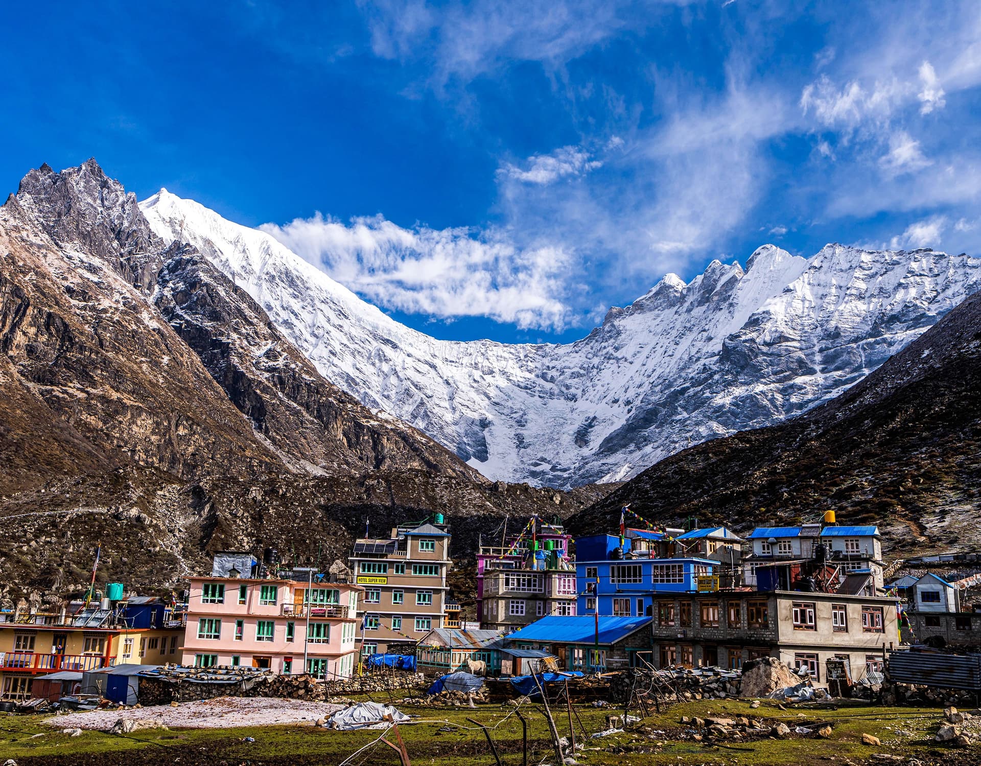
Once you reach the height of 3,000 meters, you emerge from the narrow gorge into a majestic U-shaped valley. The lush vegetation gives way to an alpine zone, where there are now wider grassy fields and grazing animals like yaks rather than trees. The most prominent feature of this section of the trail is the imposing Langtang Lirung mountain peak that towers ahead of you. There will be a chance to pay respects to the remains of the old Langtang village (buried in the 2015 avalanche), and rest in a new, recently built village beyond it.
4. The Base of the Glacier (Langtang Village to Kyanjin Gompa)
A short but beautiful morning walk will bring you to the last stop of the trek: Kyanjin Gompa. On both sides of the trail, you will find numerous Mani walls (stones with prayers) and Buddhist prayer chortens (monumental piles).
Kyanjin Gompa is a stunning village located in an amazing amphitheatre surrounded by towering snowy peaks. Here, you can taste the unique and delicious yak cheese manufactured in a state-run factory according to traditional recipes. Another attraction of Kyanjin Gompa is a centuries-old monastery, after which it was named.
5. Achieving the Apex (Tserko Ri or Kyanjin Ri)
This is the highlight of your trip! An additional day at Kyanjin Gompa allows you to make one last trek up the mountain, choosing one of the following options:
Kyanjin Ri (4,773m /15,659 ft): An easier half-day trek to a rocky ridge that will present you with an incredibly beautiful 360-degree view of the Langtang glacier and frozen ice structures below.
Tserko Ri (4,984m / 16,351 ft): A more difficult climb, which requires you to start early in the morning. We will be rewarded with a scenic panoramic vista of peaks such as Dorje Lakpa, Gangchenpo, and others, stretching all the way to Tibet.
6. Coming Down (Kyanjin Gompa back to Syabrubesi)
Since your body acclimatised well to the altitude and the path goes predominantly downhill, coming back to the starting point is unexpectedly easy. It will take no longer than two days for you to reach Syabrubesi comfortably, breathing in the rich oxygen of the forest again.
Pikey Peak Trek
According to the famous mountaineer Sir Edmund Hillary, the Pikey Peak trail provided him with the best views of Mount Everest he ever experienced. It is not too high but offers an impressive panorama of the entire range of Himalayan summits.
Detailed Schedule of the Route:
Day 1: Drive from Kathmandu to Dhap Bazaar (2,850m)
Day 2: Trek from Dhap to Jhapre (2,820m)
Day 3: Trek from Jhapre to Pikey Base Camp (3,640m)
Day 4: Early-morning ascent to Pikey Peak (4,065m); descend to Junbesi (2,700m)
Day 5: Trek from Junbesi to Phaplu (2,470m)
Day 6: Drive/fly from Phaplu to Kathmandu
Crucial Facts:
Must-have permits: Gaurishankar Conservation Area Permit (GCAP) and TIMS card.
The Feel: Quietly different to the adjacent Annapurna area, it offers an authentic experience of traditional Sherpa life.
The Pikey Peak Trek is truly an unspoiled pearl in the Lower Khumbu region (Mount Everest). Are you looking to take a peek at the highest mountains without all the hassle, high prices, and crowds around Lukla? Then this trip might be perfect for you!
Why Should You Pick the Pikey Peak Trek?
Sir Edmund Hillary's Favourite View: According to the legend, Sir Edmund Hillary described the view from Pikey Peak (4,065m) as the best view of Everest in all of Nepal. This is thanks to the trail's special position, which offers a complete view of the scale of these giants.
Seven-Eight-Thousanders Viewpoint: From there, you can see not only Everest itself but also six other eight-thousanders: Mount Lhotse, Mount Makalu, Mount Kanchenjunga, Mount Cho Oyu, Mount Manaslu, and Mount Dhaulagiri – as well as the holy Numbur Himal directly in front of you.
Bypasses Lukla Flights: You do not have to worry about the difficult flights to Lukla because the entire trek is done by overland jeep drive from Kathmandu.
Authentic Cultural Experience: Contrary to the commercialised trails of the popular EBC, this itinerary is set through the authentic Sherpa and Rai settlements, with less developed teahouses and more genuine hospitality.
Short but Not Easy: The maximum elevation is 4,065m, but the gentle climb makes it ideal for beginners, families with kids, or anyone who simply cannot devote two weeks to the trip.
Detailed Description of the Trek and Its Schedule
The trek follows a point-to-point route, going from Dhap Bazaar to the airport town of Phaplu or to the jeep station at Chaurikharka, for a total of 55–65 kilometres.
Day 1: Kathmandu to Dhap Bazaar:Drive: 7–8 hours | Altitude: 2,850m.
You will leave Kathmandu in your own jeep vehicle and start moving north along the BP Highway on the eastern side of the river Sunkoshi. Gradually ascending through terraces of farmlands and small towns, you'll reach Dhap Bazaar, marking the beginning of the trek route.
Day 2: Trek from Dhap to Jhapre:Hike: 4–5 hours (14km) | Altitude: 2,920m.
Your first day's trek starts in Sigane, where you can catch your first view of the peaks of the Numbur Himal. Following a ridge trail covered by pine and rhododendron trees, you'll reach the small Sherpa settlement of Jhapre with its beautiful Buddhist temple.
Day 3: Trek from Jhapre to Pikey Base Camp:Hike: 5–6 hours (13.7km) | Altitude: 3,640m.
After climbing through the hills of Jhapre, the trail enters the alpine zone, passes the Bhulbhule ridge, and offers a beautiful panorama. On the way to Base Camp, you'll be passing ancient yak pastures and shepherds' huts, a long Mani prayer wall, and finally a dense forest beneath Taklung Danda.
Day 4: Ascent to Pikey Peak Summit and descending to Junbesi:Hike: 6–7 hours | Altitude: 4,065m (summit) / 2,700m (Junbesi).
Rising around 4:00 AM to begin the steep climb of one hour to reach Pikey Peak (4,065m) and enjoy the magnificent sunrise over Everest, Makalu, and Lhotse. Having absorbed the incredible 360-degree panorama, you'll return to the base camp for breakfast, then descend to the picturesque Sherpa village of Junbesi.
Day 5: Hiking in Junbesi:Hike: 3–4 hours | Altitude: 2,700m.
This day is dedicated to exploring Junbesi, one of the most beautiful Sherpa villages in Nepal. Here you can hike up to Thupten Chholing Monastery, an old Tibetan Buddhist temple where you can meet praying nuns and monks.
Day 6: Junbesi to Phaplu:Hike: 5–6 hours (13.4km) | Altitude: 2,469m.
As the last part of the trek, you can enjoy hiking through Junbesi Khola and across a steel suspension bridge to Beni Ghat, then continue on an easier route to reach the busy Phaplu settlement. In the evening, feel free to visit the nearby Chiwong Monastery.
Day 7: Drive to Kathmandu from Phaplu:Drive: 9–10 hours | Altitude: 1,400m.
Board a morning jeep from Phaplu to make the long, winding drive back to Kathmandu, concluding your Himalayan loop.
Mardi Himal Trek
An alternative ridge route that will take you close to the foot of the sacred Machapuchare (also known as Fishtail).
Short Itinerary:
Day 1: Transfer from Pokhara to Kande; hiking from Kande to Australian camp / Forest camp (2500 m)
Day 2: Hike from Forest camp to Low Camp (2970 m)
Day 3: Hike from Low Camp to High Camp (3550 m)
Day 4: Climb to Mardi Himal Base Camp (4500 m) or Viewpoint (4200 m); descent to Badal Danda
Day 5: Hike from Badal Danda to Siding village; return to Pokhara
Key Facts
Must-have permits: ACAP and TIMS card
Terrain note: Unlike some treks in the area, which follow valley floors, the Mardi Himal trek takes you up a ridge providing wide views from both sides of the trail.
Mardi Himal is the ideal choice if you crave proximity to the enormous Himalayas and would rather enjoy the view without the crowd usually found along classic routes. Located in the Annapurna region near Pokhara city, Mardi Himal is a recently discovered "hidden gem" offering an exclusive chance to trek one of the world's rarest paths, bringing you literally face-to-face with the holy peak of Fishtail in just a few days.
What Makes Mardi Himal so Special?
Clean and Not So Much Visited: Unlike Poon Hill or the ABC trek, which tend to be very crowded during the season, the Mardi Himal trail remains pristine and untouched.
The Ridge Walk Experience: All treks in Nepal go via deep gorges, hiding peaks from your sight until reaching the end point. In contrast, the Mardi Himal route climbs up directly onto a mountain ridge. By day three, you find yourself above the clouds with magnificent 7,000-meter peaks surrounding you on both sides.
Spot Closest to Machhapuchhre Peak: Machhapuchhre (or Fishtail – 6,993 m) is the holy peak of the Hindu god Shiva that cannot be climbed due to its sanctity. No matter how many treks you make, there is no closer point to this majestic mountain than Mardi Himal.
Budget and Short Duration: The Mardi Himal trek can be completed in 4 to 5 days from Pokhara, making it affordable and time-efficient.
Route Description and Key Features of the Trip
This route starts in the Annapurna area, climbing up the north-south ridge separating the watersheds of Mardi Khola and Seti River.
1. Subtropical forests – Kande (1,770 m) to Forest camp (2,600 m)
Altitude: 1,770 to 2,600 m
Description: Most travellers transfer from Pokhara to Kande to start hiking. The first stage involves climbing gently upwards through cultivated areas, rural Gurung villages, and a forest of oak and giant maple trees. Passing through the famous grassland plateau called Australian Camp, you enter deep jungles that lead you to Forest Camp, also known as Kokar.
2. Cloud Forest to the ridge – Forest camp (2,600 m) to Badal Danda (3,210 m)
Altitude: 2,600 m to 3,210 m
Description: From now on, you are going through the cloud forest all the way up to Badal Danda. There are a number of ancient rhododendron trees which will paint everything red and pink in March and April. Approaching Badal Danda means approaching the cloud forest top, where you will find a stunning view of Annapurna South and Hiunchuli peaks.
3. Alpine zone – Badal Danda (3,210 m) to High camp (3,580 m)
Altitude: 3,210 m to 3,580 m
Description: This stage marks the change from forest to alpine. Gone are the huge trees; now it is a short alpine grass. Your path will wind up following the spine of a ridge; the air will get crisp and thin with altitude. Here, you might come across a colourful national bird, the Danphe.
4. Final push to the viewpoint - High camp (3,580 m) to Mardi Himal Base Camp (4,500 m)
Altitude: 3,580 m to 4,500 m
Description: Early wake-up in the morning (usually at 4 am) sets the tone for a challenging climb. The narrow, stony trail with a drop-off on each side is not easy to walk; after passing Upper Viewpoint (4,250 m), you arrive at Mardi Himal Base Camp (4,500 m), where you enjoy spectacular views of Annapurna Sanctuary.
DAY 5.Trek to Sidding (1700 m) – 6 hours.
After having an amazing day in base camp, we will descend towards the Siding village today. We will complete the circuit through Siding Village rather than return along the exact route to the forest camp and Potana. Trekking through less-visited areas with beautiful traditional villages will feel quite lovely for you. Finally, after passing through a couple of settlements, you will reach the traditional village of Siding. Here, you will meet very friendly people and have the chance to explore the village's culture. Moreover, today will be your first time staying at a homestay run by a local family.
Max. Elevation:1700 M
Duration:6 Hours
Distance:14 KM
DAY 6.Trek to Lumle -3 hours & Drive to Pokhara (800 m) – 2 hours.
After breakfast at the homestay, you will walk to Lumle village, which shouldn't take more than 2.5 hours. After you reach Lumle, you will drive to Pokhara via Kalimati and Ghalel, a 2-hour drive. We will drop you off at a wonderful hotel on Phewa Lake when we get to Pokhara. The night will be spent here, and the remainder of the day is up to you.
Max. Elevation:1738 M
Distance:5.16 KM
DAY 7. Drive to Kathmandu -6 hours.
The travel back to Kathmandu is taking place today. You can either fly or drive back to Kathmandu. After breakfast, one of our guides will drive us to the bus stop for the tourist buses to Kathmandu. You will reach Kathmandu after you choose any of the alternatives. Once you arrive, we will take you to the hotel of your choice so you can relax and explore the town for the remainder of the day. Overnight at the hotel in Kathmandu.
Max. Elevation:1300 M
Duration:6 Hours
Distance:200 Km
DAY 8. Departure from Nepal.
The moment to say goodbye has finally arrived after several days of enjoyment and excitement. Today, one of our kind representatives will transport you to the terminal at Kathmandu International Airport three hours before your departure. We are confident that your trip to Nepal was a special occasion filled with great memories and experiences. We hope to see you again on another thrilling vacation in Nepal. Happy journey!
Max. Elevation:1300 M
Everest Panorama Trek (Hotel Everest View / Tengboche)
This itinerary is ideal for those who wish to witness the Mount Everest range firsthand but don't have the time or energy to undertake the exhausting two-week journey to Base Camp.
Typical Itinerary:
Day 1: Flight to Lukla (2,840m) + trek to Phakding (2,610m)
Day 2: Trek from Phakding to Namche Bazaar (3,440m)
Day 3: Day of acclimatisation and leisure in Namche Bazaar, followed by a short trek to Hotel Everest View (3,880m)
Day 4: Trek from Namche Bazaar to Tengboche Monastery (3,867m)
Day 5: Trek from Tengboche down to Monjo or Lukla
Day 6: Flight to Kathmandu from Lukla
Brief Info:
Necessary Permits: Khumbu Pasang Lhamu Rural Municipality Permit and Sagarmatha National Park Entrance Permit. (NOTE: Standard TIMS card isn't required in Khumbu).
The Everest Panorama Trek (also known as the Everest View Trek) is a wise choice for anyone who doesn't plan to go all the way to Base Camp but still wants to experience the excitement of the Everest region. This trek allows us to enjoy the stunning landscapes of the Everest region without enduring an exhausting two-week process.
Why choose the Everest Panorama Trek?
Less Time, More Views: It takes 12-14 days to make the whole trip to EBC. With this itinerary, one can experience incredible views in just five to seven days.
Low Altitude, Low Risks: As the highest point of this trek (Tengboche Monastery) is at 3,860m, the risk of developing AMS symptoms will be minimised.
Suitable for Everyone: One will need moderate physical preparation and no special mountaineering skills.
Meaningful Cultural Experiences: This itinerary focuses on authentic Sherpa culture, so you'll have a chance to immerse yourself in the unique atmosphere of monasteries, mountain museums, and trading hubs.
Everest Panorama Trek Main Route and Attractions
One should expect this route to follow the legendary path of the EBC trek, crossing the Dudh Koshi ("Milky River") valley before returning via its highest and most picturesque sections.
1. The Start Point: Lukla - Phakding
Elevation: 2,860m to 2,610m
Distance: 3 km
The Experience: The experience begins with a breathtaking aeroplane flight into the valley, followed by an easy walk down, crossing a couple of suspension bridges and praying stones (manis).
2. The Hardest Part: Phakding - Namche Bazaar
Elevation: 2,610m to 3,440m
Distance: 7-8 km
The Experience: Upon arrival at Monjo, the gate of the Sagarmatha National Park, you will walk the road surrounded by pine forests along the riverbed. After crossing the Hillary Suspension Bridge (famous for the movie "Everest"), you will climb steeply into the forest, obtaining first glimpses of Mt. Everest. Namche Bazaar, the capital of the Khumbu region, is home to most of the tourist infrastructure.
3. Panorama Hub: Namche and Syangboche
Elevation: 3,440m to 3,880m
Distance: 3 km
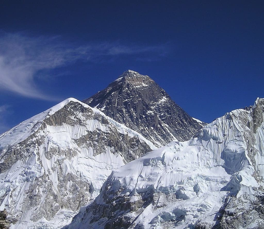
The Experience: After some rest in Namche, one can visit Syangboche, known for amazing views of Mount Everest (8,848 m), Lhotse (8,516 m), and the magnificent Ama Dablam (6,856 m). One can also drop by the village of Khumjung to visit the local monastery (infamous for keeping the "Yeti scalp").
4. The Spirit of the Place: Tengboche Monastery
Elevation: 3,440m to 3,860m
Distance: 5-6 km
The Experience: Depending on the itinerary type, trekking will continue further from Namche Bazaar, descending to the small settlement of Phunki Tenga. The next part of the journey will involve a steep climb through the forest to the ridge at Tengboche. At the top of this ridge, on one of the best viewpoints in the Khumbu region, sits the largest and most important Tibetan monastery. Watching the sunset behind Everest and Ama Dablam and listening to the monks' singing in the monastery is an incredible spiritual experience.
Ghandruk Circuit Trek
The absolute easiest and most comfortable option on this list. It involves trekking at lower altitudes to enjoy the picturesque stone villages and the hospitable nature of the Gurung people.
Short Itinerary:
Day 1: Drive from Pokhara to Kimche, trek to Ghandruk (1,940m)
Day 2: Visit Ghandruk village, trek up the hills to Landruk (1,560m)
Day 3: Trek from Landruk to Phedi and return to Pokhara
Essential Information:
Permits Required: ACAP and TIMS card.
For Whom It Is Suitable: Absolute beginners, older adults, or families trekking with kids.
Annapurna View Trek
This itinerary will let you walk at low altitudes in the Annapurna foothills while enjoying spectacular views of the Annapurna massif. There is no need for lengthy and exhausting ascents.
Short Itinerary:
Day 1: Drive from Pokhara to Phedi, trek to Dhampus (1,650m)
Day 2: Walk from Dhampus to Landruk (1,560m)
Day 3: Trek from Landruk to Ghandruk (1,940m)
Day 4: Walk downhill to Nayapul and then go back to Pokhara
Essential Information:
Permits Required: ACAP and TIMS card.
Reasons to Go For This Trek: It provides an easy circuit of the best views of the south slopes of the Annapurnas.
What Should You Pack for Your Short Trek?
These treks do not involve entering the cold alpine region. Therefore, you do not have to worry about packing heavy gear. Just pack your clothes and necessities into a 30– 40 L daypack.
Footwear: Comfortable trail-running shoes or lightweight trekking boots.
Layers: A thin fleece jacket, a rain/windproof jacket, and a down jacket to keep you warm at the top of Poon Hill in the morning.
Must-Have Accessories: Adjustable trekking poles to protect your knee joints when descending the stone stairs; polarised glasses, headlamp, and warm beanie for sunrise.
Hydration: Reusable plastic Nalgene water bottle and some water purification tablets.
FAQs About These Treks
Do You Need a Licensed Guide for these Trekking Tours?
The answer is yes. According to the Nepal Tourism Board, all foreigners who plan to hike in Nepal must travel with an official government guide. These treks will provide an easy way to both hike and learn about the local traditions of Nepalese mountain communities.
What Will Be My Accommodation?
You will stay in local teahouses. Teahouse is a mountain lodge that is quite comfortable at these altitudes (it offers twin-sharing rooms, plenty of food, including famous Nepalese dal bhat or Italian pasta dishes, power supply for charging electronic devices, and hot showers for an extra charge).
Will I Get Altitude Sickness on These Trails?
No risk of it here. Acute Mountain Sickness (AMS) can appear above 2,500 m, but serious symptoms will only develop if your altitude overnight exceeds 4,000 m. Low peaks and moderate elevations on your treks give you enough time to adapt.
Can I Travel in Running Shoes?
You may consider trekking in shoes with good traction and ankle support. These trails are in perfect condition; still, there are uneven stone roads, exposed ground, and muddy sections.
Conclusion: Himalayas Made Easy
It is unnecessary to possess the skills of a mountaineer or be an extremely active person to appreciate the world's grandest mountain scenery. Short treks are a good way to explore Nepal without reaching very high elevations.